Trip Blog
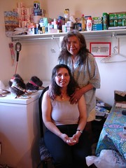
Terry and Carol in their store at Tsiigehtchic
Bike Touring The Dempster Highway - Our Report
- Resources
- The Milepost is essential. Copy or rip out the section about the Dempster and you'll know where every pullout and campground is.
- Alys and Pete's book Alaska Bicycle Touring Guide is getting mighty old, but it's the only place you can find out where water is available. That's something that matters to a cyclist and not to most other travelers.
- Journals from other riders who did the Dempster: Jeff Kruys (2006), Murray Snyder (2006), Mike Vermuelen (1996)
- Things you'll need
- Mosquito headnet (or full body suit) and repellent. Mostly we liked the headnet instead of repellent.
- Bear Cache/Cannister (or see our note on using garbage cans as a cache)
- Eye protection - lots of dust and things flying.
- Water capacity enough for the 100km section of no water between Eagle Plains and where the Ogilvie River leaves the highway.
- Water filter or chemicals
- Spare tire and tubes. We had no problems, but plenty of cyclists and motorists have had destroyed tires from the sharp shale sections.
- General notes
- Don't forget that you can't get across the Mackenzie or Peel Rivers during freezeup or breakup. You'll need to know when the road is likely to open if you want to travel those stretches.
- You can send half your food ahead to Eagle Plains - mark the box with your name and "please hold for cyclist". You can typically arrange this at the visitor center in either Dawson City or in Inuvik. There are a lot of kind motorists travelling this route.
- Almost everybody travelling this road is actually a friend and a support vehicle. In case of bike trouble, water trouble, etc., you'll probably come out OK by asking for help.
- The road was pretty fair quality dirt road when we went. It's way better than most dirt roads I've travelled, both in terms of grade and quality. However, some sections turn to horrendous mud in the rain, and of course cyclists hate the mud. You may want to leave your fenders at home.
- You can camp at gravel pits, rest stops, etc., in addition to the campgrounds. In a number of places it's hard to camp on the swampy or permafrost areas off the highway except in these places.
- Spend some time hiking at Tombstone if you can.
- Eagle Plains Hotel had fair prices (only $10/night for camping - included the shower! - although there was a place for quarters you didn't have to use it.)
- You can buy some food from the kitchen at Eagle Plains, but they don't have anything in their store. But you can probably get a loaf of bread, for example.
- Engineer Creek Campground has unthinkable water. Get water just downstream at the Ogilvie River bridge instead and haul it to the campground.
- Fort McPherson has most services, but Tsiigehtchic (Arctic Red River) has basically none.
- Tires and bike: I used a mountain bike with Continental "Traffic" tires, and Nancy used a touring bike with Shwalbe Marathon XR tires. These worked great. I do recommend some tread and a wider tire for this route.
- The 100km section between where the road leaves the Ogilvie River (northbound) to Eagle Plains has no good water. Plan to get water there or at Eagle Plains (southbound) for this section. A motorist might cache some water for you at a kilometer marker as well. Kilometers are marked on even kilometers and most of the markers are there.
Delightful trip to Whitehorse
We made it to Whitehorse, the capital of the Yukon. We had a great trip - some new friends, some rain, some sun. A bit slower than we had expected.
When we rode into Whitehorse we saw the first traffic light of the trip. We've been almost 800 miles without seeing a traffic light! Where can you do that?
Today our friend Rob Ungless is flying in from Vancouver and we're going to ride down to the sea and visit southeast Alaska. I don't expect to be able to post anything more for a few days, but hopefully we can get you some pictures of the wonderful Klondike and Yukon area.
In Juneau - and links to Klondike + Juneau PIctures
And here are some new pictures from the most recent two legs of the trip:
- Dawson City to Whitehorse: all (float over for descriptions) or slideshow
- Whitehorse-Skagway-Juneau-Haines Loop: (updated again July 14)all (float over for descriptions) or slideshow
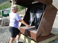
Using a bear-proof trash can as a bear cache/bear cannister
Rosie around the World
Klondike Country - the Keno Paddlewheeler
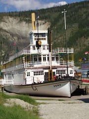
What's amazing to me is that sternwheeler steamboats plied the Yukon until 1956! That's after I was born. It was really the only way to get to Dawson until the highway was built in 1953. Dawson is an isolated place.
And the next step of amazing is that the steamboats served the entire Yukon: 2000 miles from Whitehorse to the Bering Sea. Every time we pass the Yukon or a tributary (like the Eagle, which we crossed on the Dempster) I want to get in a canoe and float to the sea. It would take a long time!
Sternwheel Steamer Graveyard
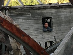
This picture is taken near midnight, just for perspective - maybe after midnight. This is our friend Oliver in the cabin of one of the old steamers.
Leaving Whitehorse for Skagway with Rob Ungless
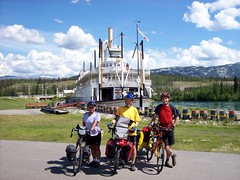
Here we are in front of a Whitehorse landmark, the Klondike steamer. It's much larger than the one we saw in Dawson, and it ran the river from here to Dawson.
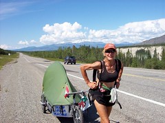
Nancy pedaling her way furiously to Juneau
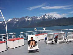
Well, there's no way to get to Juneau on a bike except to get on the ferry. Aw, shucks. It was hard, bad weather and everything.
It was a glorious day, blue skies, amazing mountains. And a welcome rest.
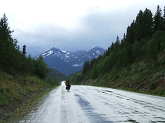
Headed down the Cassiar Highway
We're leaving Whitehorse in the morning and will spend 5-7 days on the Alaska Highway getting to Watson Lake, where we'll resupply and then backtrack a few kilometers and head south on the Cassiar Highway. The Cassiar is a beautiful, little-travelled alternative to the Alaska Highway that runs south to near Prince Rupert. It's about 80% paved and about 500 miles long. Probably not much internet access :-) Many people report seeing lots of bears on this route (no trouble with them). And there's a famous trail at Stewart where you can watch the bears catching salmon - we might get to see that.
We'll check in with you down the road!
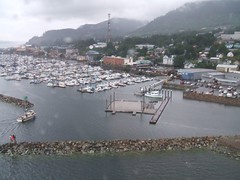
You are HERE: Watson Lake
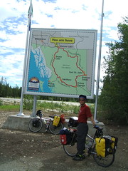
Watson Lake Signpost Forest
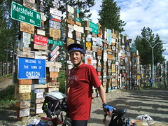
Nancy put our "hobobiker" card and sticker in a ziplock and duct-taped it to the back of a metal sign. It's not much in this incredible forest, but it's lightweight and minimalist for bike tourists :-)
Big Trip Canada Photos (Summer, 2006)
- Starting out: Dempster Highway - Inuvik to Dawson City photos: all (float over for descriptions) or slideshow
- Dawson City to Whitehorse: all (float over for descriptions) or slideshow
- Whitehorse-Skagway-Juneau-Haines Loop: all (float over for descriptions) or slideshow
- Alaska Highway all or slideshow
- Cassiar Highway all or slideshow
- Vancouver Island all or slideshow
His Mama didn't train him right
We have had some really nice road and some excellent motorists. In fact, we'll look back on the Cassiar and Klondike and Dempster highways with fondness because the traffic was light and the riding good.
But there are a few motorists whose Mama just didn't train them right.
I'm sure *your* Mama taught you that when passing a cyclist or a pedestrian on a dirt road or in the rain that you should slow down so you don't slop all over them. And didn't your Mama teach you to give a cyclist a wide berth when passing... and if you can't pass safely right now, then slow down and wait until you can.
Most of them are great, some some can use some more training!
Touring Cyclist Tip: Cleaning your chain on the road with diesel in a peanut butter jar
- We're using the SRAM quick-connectors on the chain, so we just took opened the chain up using those. (Nancy has a Shimano chain, and the connector works on those, too.) If you didn't have that, you'd have to break the chain the old fashioned way.
- After removing the chains, we put them in a bit of diesel in a small peanut butter jar and shook and let it sit awhile.
- Then I wiped every link carefully with a rag
- Finally, we let the chains dry just a bit, then applied some new lube.
- And the next day we put more lube on, because the diesel remaining in the chain dissolved a lot of the original lube, of course.
Breakdowns!
And then approaching Dease Lake in a horrible dirt-road section I broke a spoke in my rear wheel. We spent a day cleaning up and repairing and resupplying, and then spent a couple more days resting in Telegraph Creek.
But the day we started out again on the Cassiar, I immediately broke ANOTHER spoke. This time, the spoke was one of the harder ones to replace and I had to use a special Hypercracker tool to try to get the cassette off the wheel. I broke the Hypercracker right away. We tried to use it several other ways, but completely failed. The Hypercracker was destroyed and my spoke was still broken. We started looking for alternatives, but found none. We asked everybody we met as I wobbled by on my bike whether they might know somebody with some bike tools. We failed until meeting Johann at Tatogga Lake, who told us he had what we needed at his house in Stewart 225 miles away (and on our planned route). So we kept going, figuring we'd hitchhike if it all blew up. But we made it to Stewart and got the wheel fixed and it seems like it will be OK!
So the bike is better and after the rests we had at Telegraph Creek and Stewart we feel all better and healthy and happy with what we're doing!
Touring Cyclists' Report on the Cassiar Highway
- The Cassiar is a cyclist's delight, even though we had a fairly rough time with it. The traffic is light, the road is generally good, and the services are more frequent than we expected.
- The road is mostly paved (about 90%) and not too difficult. There are plenty of hills, but no huge passes. The 10% that is not paved can be fairly difficult (it was all mud for us, and we hate mud). But it's not really all that bad. They expect to finish all the paving in the next couple of years.
- We found groceries at several places we didn't necessarily expect them. The stores at Good Hope Lake, Dease Lake, Iskut, and Stewart all had groceries. All of those except Good Hope Lake had excellent variety. However, there was nothing at Meziadin Junction. The kind woman at Moose Meadows (north of Dease River Crossing, which is north of Dease Lake) also stocks some imperishables just for the cyclists who come through.
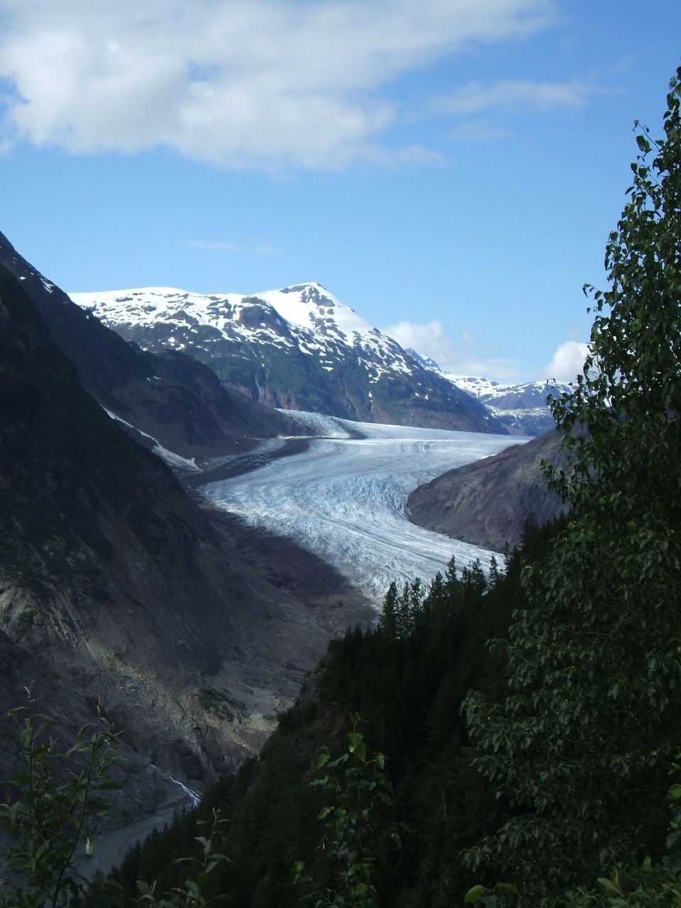
- Go to Stewart and Hyder. You'll regret passing them by, even though they're off the route. You'll want to see the glaciers and the bears at Fish Creek!
- Coming from North to South we went to Watson Lake to resupply, but we probably didn't have to, because we could have figured something out by getting enough food at Teslin and then getting a little at Good Hope Lake to get us into Dease Lake.
Cassiar Highway and Beyond, way beyond.
[Note that NEW PHOTOS are posted on the Photos page...]
I can not even remember how long it was since we started our ride south on the Cassiar Highway, since the bugs ate me alive at the Junction of 37 and the Alaskan Highway.
Was it a week ago we started, or was it two or three ago. I can not even remember what day today is. It is not that I have a memory problem or any more then usual. It is just days and nights run into each other and all the markers that keep track of the day are left behind when we travel each day to a new place.
There is a common thread that keeps it all together. Bugs, bugs and more bugs. There is now reason for this many bugs. I am currently trying to recover from a bite that got me a week ago in the eyelid, swelled it up so bad I look like I just got out of the boxing ring. The rain was something that dampened out spirit and has been a thread of commonality. Currently we are in Ketchikan, Alaska hiding out at Alltec Computer store updating our website which is really avoidance from going out and getting wetter then wet. It seems we really are wimps but we are working on getting ready for the West Coast ride down the USA through Oregon. Also another common thread is the amazing wonderful people we meet that share so much with us. Wow! People are really wonderful. Thank you all for your gifts of generosity.
The Cassiar Highway was great in most parts and really bad in others. Most of it is a grade A bike touring road and about 15 percent is really bad. (Pot holes holding water, mud, under construction) Randy broke a spoke so we had to try to get it fixed which we failed at so we hitchhiked past the worse part and limped to Stewart. We got rained on a lot but when the scenery cleared we had incredible vistas with snowcapped mountains, glaciated waterways and lakes, the widest range of vegetations we have seen so far. We saw a few bears, a wolverine, dear and lots of birds.
We recovered in Stewart with evening views of the Salmon at Fish creek and the occasional grizzly showing up to frolic in the water and splash around in the pools in an attempt to get his dinner. We borrowed a jeep from Tracy ( who treated us to wonderful homemade breads) and rode up to see the Salmon Glacier above Hyder, Alaska. A man called Keith lives up at the road summit overlooking the Glacier, in a tent under the sign announcing the Glacier. He is called the bear man and you can bye his stuff but what is amazing is he has been living in a tent in this area for 30 years selling his stuff. We also meet a helicopter driver who supports the crew which cuts the brush along the US and Canadian border. He had his Helicopter on the edge of the cliff at the summit. I could not believe he could do this, some people are nuts.
I like to be creative in travels so I found a way to get to Prince Rupert which would cut off a week of cycling. We hopped on the US mail plane that flies from Hyder, Alaska to Ketchikan, Alaska where we will take a ferry to Prince Rupert. It was an amazing sight to see two bikes, bike touring luggage and 4 passengers take off in this float plane called a Beaver. We flew over the Misty Fiords. The sights brought tears to my eyes. Pristine Fiords which we flew just 100’s of feet from the ridges tops in the misty August afternoon.. It is something I would recommend everyone to try.