Trip Blog
Dempster Highway Ferry Crossings
We're starting as early in the year as would be possible. In April, the Dempster is closed when the rivers start to melt, taking out the ice bridges. The highway reopens in June when ferries can operate.
The current road report shows that the ferries are not yet running on the Dempster as of May 23. If we started today, we could not ride the highway.
The historical data for the Peel River Crossing and the Mackenzie River Crossing show that the ferry usually starts running the first week of June, but in 1977, it didn't start until June 16. I don't know why we chose June 9 as a starting date because we didn't know anything about this. But I'm glad it looks like it was a reasonable date!
We are in Grand Junction where we will fly out of
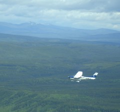
Today is June 1st, 2006 and we are really doing it, we on our way. After months of prep we are on the road but not on our bikes. We drove to Grand Junction where we will fly out of Grand Junction Airport (Walker Field) in the morning in a Cessnar piloted by Collin Fay and Marisa Fay. Collin and Marisa do this all the time with their business, Parkest Air Tours.
We are flying to Helena, Montana to meet 13 other small planes which will fly us to Inuvik and drop us off with our bikes and all the gear. We will then ride south on the Dempster Highway, a 450-mile gravel road with very limited services. What a great way to see the world.
Wish us luck and good riding weather.
Dawson Creek, BC
Today our airlift of 12 planes flew us about 800 miles today from Helena, Montana up to Dawson Creek, BC, Canada, the beginning of the Alaska Highway. Some of it was a bit choppy, but it was a successful trip.
You ask why we need 12 planes to get us to the North Country? We have no idea. When we were planning this trip, my brother Collin and sister-in-law Marisa asked if we wanted a ride up there in their Centurion light plane. We said yes. They also invited many, many of their Parkwest Air Tours clients... and all of them said YES! So it's a really big group.
Tomorrow we go on to Whitehorse, Yukon Territory if the weather works, or perhaps to Dawson City, at the bottom of the Dempster.
As I write this, the temperature in Inuvik is 2 degrees above freezing, and we're wondering if we're really ready for that kind of temperatures. The forecast is a little better than that, though, and cooler temps mean less mosquitoes...
Whitehorse, Yukon. Tomorrow we get to Inuvik!
We flew from mile 0 of the Alaska Highway all the way to Whitehorse, Yukon Territory. It's 10:11pm and the sun won't go down for more than an hour. But tomorrow the sun won't go down at all.
The flight was wonderful today - we hugged the river due to low-hanging clouds and had great views of beautiful places. The ride over the Continental Divide was spectacular.
Hope to update you more and provide some pictures from Inuvik, if we have internet access.
In Inuvik, SOUTH on the Dempster!
We made it to Inuvik and we're headed south on the Dempster Highway tomorrow morning! I'd hoped to have a picture of Inuvik for you but the library is closing so I'm rushing it.
480 miles to Dawson City. A store in Fort McPherson and the hotel at Eagle Plains are the only real things between here and there. It's almost all dirt, and of course we hear all the horror stories about it, like bears and mosquitoes and moose. I think we'll have a blast. We'll let you know in 10-14 days. We're glad to have you along with us!
We made it to the Eagle Plains Hotel!
Well, it took us six days but we made it to the halfway point on the Dempster Highway, the Eagle Plains Hotel. We've had a wonderful time - quite a stretch for us to do something this hard as the first thing on the tour, but we're well. The weather has been incredible. Because there's no night, the earth gets lots of warmth from the sun this time of year. In our first couple of days the temperature was in the 80s and 90s Fahrenheit! Really hot.
No bears! Nancy's worry level may be decreasing - she spent a lot of time talking with a woman whose extensive experience in the wild in this part of the world (and no problems with bears) gave Nancy more confidence to deal with possible encounters (and less fear that we'll have them).
And so far the mosquito season has hardly started. We have plenty of bites, but it's the kind of thing we've experienced before, not the intense disaster people talk about in July up here. However, we have a long ways to go... But we have mosquito outfits and spray and such.
Today we're taking a day off and just resting here at the Eagle Plains Hotel. We swapped a night's lodging and dinner with them in exchange for developing a website - http://eagleplainshotel.com - that they've never had before.
Beginnings
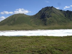
Well, we've been out for a week and have met the most amazing people. The stories that we're hearing are phenomenal. Between the stories are many incredible landscapes - the awesome Richardson Mountains that form the divide between the Arctic watersheds and the Pacific, between The Mackenzie and the Yukon.
No bears but lots of bear scat. I'm calming down a little bit.
We'll try to get some pictures uploaded and write some of the wonderful stories we've heard when we get to Dawson.
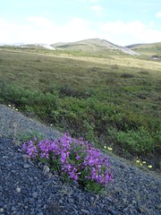
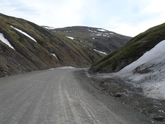
North Fork Pass
Dempster Highway Photos
We're getting showers, even when wild camping!
Christof and Gernot just starting north
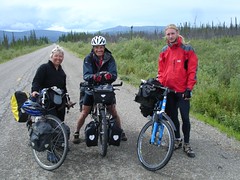
We've met quite a number of cyclists here in Dawson City. What a treat to compare notes with new friends.
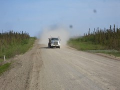
Truck bringing dust our way - near Fort McPherson
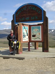
The Arctic Circle
The 24-hour day (and near-24-hour-day) that we've had is amazing. It's really light all the time. We have not used our camping headlights and won't for some time yet. We did bring blindfolds for sleeping at night and they've been fantastic.
Despite the 24-hour day, there is still a cycle to things. It cools off quite a bit at night, and warms up in the day. The insects know about the cycle and function quite adequately.
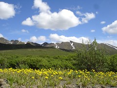
As you've seen from our pictures, nearly everything is fully summertime here, just like you'd see at home in the Rocky Mountains. Apparently, even though the sunlight is filtered by much more atmosphere to get here, the fact that it's shiniing for 24 hours means that the earth absorbs as much solar radiation in the 24 hours as it would in 12 hours at the equator, and that's the reason for the glorious summer.
North fork pass views
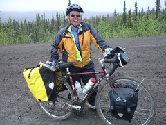
Nancy's horrible mud bike
Posted 26 minutes ago. ( permalink | delete | edit )
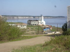
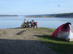
Camping at Tsiigehtchic in back of the church overlooking the rivers at Tsiigehtchic
Anthony dad, Russel, helps run the ferry which you can see in the far distance. This one just one of the three ferry crossing we have used so far. A bridge can not be built here because of the freezing and thawing of the river is too mighty it has knocked down bridges that have been built before.
We needed shower desperately so we asked Russel where we could get a shower at Tsiigehtchic. He said just go to his house and help ourselves which we did. He had a lovely home in this great village. Thanks Russel for the showers and the stories of your life. We highly recommend you all take the ferry to Tsiigehtchic and visit with the people here. Look up Carol Norwiegnin and her mom. Carol walked 125km to Inuvik to raise money for cancer. We meet he and her mom, a survivor of cancer, on the road. We have
Airstrip warning near Eagle Plains
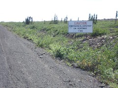
This sign has a new meaning of share the road.