Inuvik to Ushuaia
Requesting help for a worthy cause in Nicaragua
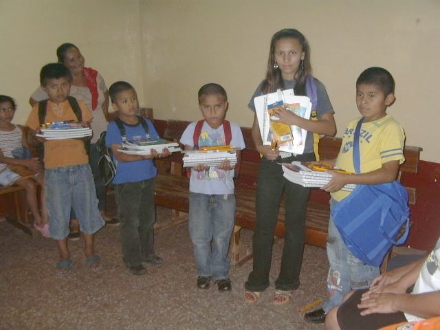
When we were in Rio Blanco, Nicaragua, volunteering for Agua para la Vida (aplv.org -- See our stories here) we met one of the key guys there, Esteban Cantillano, and he told us about one of the side projects that he´s involved with. He´s a member of the lay order of St Francis associated with the local Catholic church, and this group tries to adopt a small group of boys who are not going to school and to try to provide what they need to get going. Lots of kids end up not going because they can´t afford the basics: uniform, notebooks, and maybe a backpack.
When we were there we gave him $400 that various people had entrusted to us for something like this, and he used it to purchase 15 school uniforms and shoes for the 15 kids (he even send a scan of the receipt).
There are pictures of the kids here and a little note about Esteban that we wrote here.
Anyway, the kids need funding again this year, and they will in future years. It´s such a fantastic thing for a grass-roots local group to make a little dent in the future of the town by getting 15 or so kids into school. If you are interested in helping Esteban´s group, let us know and we´ll start an email conversation, and I can translate for you. We can help with the logistics of getting the money to them. read more here... lee mas aquí... »
Back in the US of A
We had an uneventful flight from Santiago, Chile to Miami and a delightful ride through the Everglades to Naples, Florida, where we'll be living with Nancy's dad for a couple of months before returning to Colorado. We'll put up some more pictures before long, and Nancy's editing some videos from the trip as well!
Just wanted to update you on where we are. No, we didn't fall off the edge of South America!
A Map of the Whole Trip
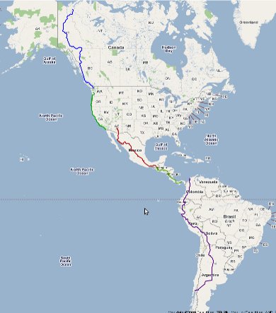
Here's a map of the whole trip. To explore in more detail (via Google Maps), click on the map or below.
Click for a bigger interactive map to explore
Some details of the trip:
- We went almost 14,000 miles (22,000 kilometers)
- Starting date: June 9, 2006
- Return date: January 14, 2009
- Biggest mileage day: 89 miles (143 kilometers)
- Number of lifelong memories: Uncountable
- Amazingly wonderful, gracious people: Uncountable
- Number of times we were threatened by bad people: 0
- Number of petty thefts of our stuff: 3
- Sets of bike tires we went through: 4
Nancy's Art

Click here for a slide show of my art.
Often during the bike trip I created small watercolors using a Winsor Newton traveling watercolor kit. I would either work out in public at busy markets, plazas, dockside, or quiet, secluded places like along the seashore, river banks or on top of mountains like Machu Picchu. I also painted in our hotel or temporary apartment from prints of photos either Randy or I took. While working outside I would often have a crowd looking over my shoulder watching each brush stroke. If someone was a little to close like the young kids and teenagers, I would start drawing them. They usual shied away from this and I would get some breathing room. Other times I would worked from a computer display or the small display on my camera. A trick I discovered to view a particular photo was to make it the last one on my memory stick by copying it. It would then be the first one I viewed when using the view feature on my camera.

A story about artists and their art who we meet along the hobobiker route: weavers, painters, carvers and so much more
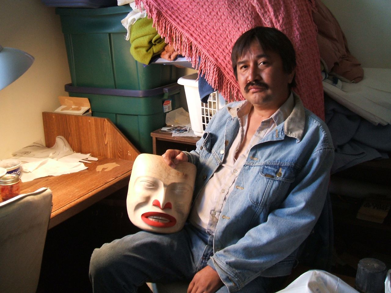
One of the special interests I had while traveling through 14 countries was seeing the different regional art. Art tells about the culture, values and links with the history of the people or a connection with the past. Much of art through out the world are traditions that are passed on from one generation to the other. This is especially true with the indigenous people of the Americas.
During the nearly three years of our trip, I would often stop and talk with the artists I met. I wanted to learn as much as I could about their art, techniques, materials and themselves.
Some of the people I sat with were First Nations Canadian wood carvers and Inuit leather workers. In the United States, I learned how to blow glass along the cost of Oregon I visited ceramic studios and fine tapestry studios in Mexico. read more here... lee mas aquí... »
Colombia: One of our favorite countries
Our Bike Trip from Canada to Argentina
This website is the story of our two and a half year trip riding almost 14,000 miles by bicycle from the north of Canada to Argentina. We're Nancy Lewis and Randy Fay, and we were 51 when we started out in June, 2006. We sold nearly everything we owned -- including our house, car and furniture -- to pedal -- and sometimes push -- our bikes through 14 countries carrying everything we would need to be self-supporting.
Our once-in-a-lifetime experience started in Inuvik, Northwest Territories, Canada in June 2006 and ended in Puerto Montt, Chile in January 2009. The purpose of this trip was to get to know the people and their cultures in a more intimate way. We didn't set any records athletically or anything - people do this every year. But we met an enormous number of fabulous people and had some incredible experiences along the way.
We returned to the United States by plane in January 2009, and have settled back into a normal life in Palisade, Colorado.
We invite you to browse our stories and pictures. If you have any questions, contact us on the contact page.
Thanks to all of you in all those countries who made this such a wonderful experience!
-Randy and Nancy
Our Sweden week's trip
Anna Wittert (Fuego Project) Leymebamba to Celendin notes
These are Anna Wittert's notes from Leymeybamba to Celendin, in northern Peru:
km 426 / 2300 m Leymebamba
km 396 / 3600 m top of the climb, there are waterstreams on either side of the pass, not so much or unclean water lower down
km 376 / 2500 m restaurant (blue building, i think the one you stopped at as well, cause all the busses have a break at this one, we were allowed to camp and cook inside for free as it was raining and the slopes closeby to steep to pitch). They have a watertap outside. The town is called saulluma, and the restaurant Diegito, but there are no signs to tell you so.
km 336 / 980 m Balsas (shops and I think a bad hotel)
km 331 and km 324 reasonable looking campspots, although hot and with a lot of cactus
we carried 20 l of water from the first pass down and used that at the restaurant and carried the rest for the next night. Not really necessary in the end, although it was nice to drink fresh mounbtain water for a change...
the climb from Balsas is a little bit steeper then the one from Leymebamba, especially the bottom 20 km
km 315 Limon (small town)
km 314 a small track in a sharp left bend on the right side of the road, lined by an old stone wall, leads to farmland. We asked the farmer and camped some 40 meters away from the road. No water on site. Awesome birds both evening and morning.
There are a few more suitable wildcamp spots further up, but all visible from the road. The cliffs get too steep for camping after a while.
km 293 / 3145 m the top! good camping options if you don´t want to go to town
km 281/ 2680 m Celendin
Anna WIttert (thefuegoproject.com) notes from Cajamarca to Trujillo Peru on the back roads
Cajamarca to Trujillo on the backroads....
General. Nice ride, maybe not as impressive as the ride north of cajamarca. Not much traffic. Pelenty of small towns to stock up and get a room. Overall the condition of the road was pretty good, and the climbs gentle. I would imagine the stretch from Agallpampa to Shorey the other way around would be pretty steep.
NB take mosquito repellent, lots of zancudos!
day 1 Cajamarca to San Marcos
65 km paved
cajamarca to banos del inca 5km
turn right
the kilometer posts start counting up from 0 here
km 9 start of climb, small village
km 17 top at 3010 m
km 25 Namora, end of downhill 2785 m
km 36 uphill starts
km 38 Matara (small village)
km 41.5 top (2995)
km 45 -50 undulations
km 50 downhill starts
km 60 San Marcos 2375 m (slept at police station in the cell, not recommendable, unless you like bunkers)
Day 2 San Marcos to Cajabamba
61 km paved (road markers count on upwards)
km 60 - 74 climb to 2700 m, gentle, plenty wildcamp options
km 74 - 89 downhill to 2100 m
km 89 - 97 undulations
km 97 - 120 climb to 2700, hot, small villages on the way
Nice hotel, hotel Bolivar, 2 blocks from plaza, 10 soles, downstairs, courtyard
Day 3 Cajabamba to Huamachuco
56 km unpaved
km 0 - 32 mostly uphill to 3400, good dirt
km 32 - 40 down to 3220
km 40 - 44 around laguna sausacocha, flat
km 44 - 56 bad dirt, rocky and sandy with 2 steep shortish climbs
Huamachuco nice hotel, El Conquistador, 15 soles, courtyard, hot water, meals, 2 blocks from square
Day 4 huamachuco to Shorey
61 km
mostly paved read more here... lee mas aquí... »