rfay's blog
Route through Honduras
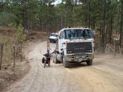
You may remember our friend Tim Malloch that we met in the north of Mexico, in the Copper Canyon region. He was headed north, and we south, and like all travelers we meet, we pestered him with lots of questions about his route and his favorite places along it. We remembered him telling us that the back roads from Santa Rosa de Copan to La Esperanza were his favorite section in all of Central America. So we set out to follow his route. We suspected, but didn't know, that it would continue the really tough mountainous route that we'd already been struggling with in Guatemala. But we took it, and he was right, it was delightful. We spent several days with nearly no traffic, delightful pine-covered hills, and interesting people tucked back in remote valleys. We passed by little roof-tile making operations (apparently the clay is good in this area) and climbed through some of the most remote areas we've been in since northern Mexico. In one town we found no available hotel or "hospedaje" (cheap hospitality) but the mayor happily opened up the municipal offices and settled us in the community meeting room. We had all the comforts of life including a bathroom and a cold shower (which was one of the lesser cold showers we've had). read more here... lee mas aquí... »
Copan Ruins in Honduras
Our first stop in Honduras (and one of the reasons we chose the route we did) was the famous Mayan ruins of Copan. We dragged in at the end of another 3-day stretch of riding these mountains (about the best we've been able to do before resting at least a day). Nancy was sick with some kind of stomach thing and we were both finishing off colds. (All of these ailments are long gone now, thankfully.)
So we weren't at our best the next morning when we went to the ruins. We spent the entire morning there, and hired an English-language guide to explain it all. But we were all the time just feeling like we wanted to be in bed or getting something to eat, which is not what you want when you're at one of the world's most famous and important archaeological sites.
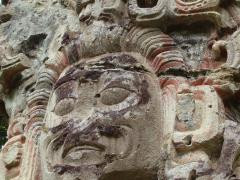
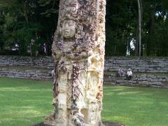
Despite our sorry state, we really appreciated the artistic beauty of the place. We've been to several other Meso-American ruins, and the beauty of the stelae (tall stones that tell a story) and other engravings was just off the chart. Somehow they really developed a much more artistic way of doing all the hieroglyphic writing here.
The environs are beautiful green luxuriant growth, like at Palenque, but the structures are considerably smaller.
Probably the most significant thing we've taken away from Copan was the enormous connectedness of the ancient Mesoamerican world. read more here... lee mas aquí... »
Coffee Harvest
The areas we've been riding through on Guatemala and Honduras are all full-bore into the coffee harvest. Coffee is everywhere, and it's really interesting to see where that brew comes from.
On the picking side, we've met little kids with mayonaise jars and whole families, each with a home-made bucket. They work as hired hands, getting paid about 1 lempira, or 2 cents per pound of picked coffee. A family can pick a fair bit in a day - maybe each of the kids can pick 40 pounds, bringing in US$2.00. This time of the harvest can be the primary cash earning time of many of these campesino families.
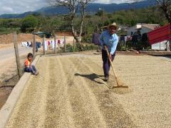
We met Carlos, on the complete upper end of the coffee spectrum, at a hot spring in Gracias, Lempira, Honduras. He is a coffee taster, employed by the Guatemalan national coffee testing laboratory, and he helped us understand some of the details about the harvest. He mentioned that US people have a tendency to disapprove of small children being involved in the coffe harvest, but here it's a longstanding tradition, and beneficial to the families. Carlos also explained what makes coffee good (bigger beans, shade grown, mountains, etc.) and what the various grades of coffee are, and how world price fluctuations affect this region (a lot!)The coffee bean off the bush is a largish green thing, which has to have the outer fleshy part ripped off with a machine to leave the inner bean. This step of the harvest is invariably done with a machine. Then the coffee is left out in the sun for three days to dry. read more here... lee mas aquí... »
Guatemala Reprise: New Pictures and Route Update
Here is a slideshow of the pictures from the last week or two in Guatemala (plus the Copan Ruins in Honduras). You can view all the pictures in full size and with their captions on flickr.
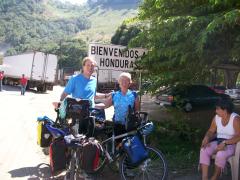
Entering Honduras, our 5th country!
There are new pictures posted and the route information is up-to-date so you can see our route through Guatemala.
We finally entered the 5th country on our trip, and once again we're sad to leave a delightful place. Guatemala was great to us, if we don't blame it for the whooping cough :-)
We had to pay $1.30 to leave Guatemala and $3 to enter Honduras, but there were no problems of any kind. We even got the exchange rate we asked for when changing our Guatemalan Quetzales into Honduran Lempiras. Lots of friendly talk with everyone around. The border post where we crossed is a bit of a backwater, which helps, I'm sure, but the people sure were good to us. read more here... lee mas aquí... »
Climbing the Pacaya Volcano
Views from Pacaya Volcano
One of the delightful touristy things you can do in Antigua Guatemala (the beautiful gringo touristy old colonial city just a few minutes from Guatemala City) is you can climb the Pacaya Volcano and see the lava flow there. For $5-$10 you get a bus ride to the trailhead (about 2 hours away by slow bus) and a guided hike up to the lava flow at dusk. What a treat it is! I've never seen a lava flow before, so this was great. We climbed up a steepish trail for perhaps 45 minutes before getting to the cold lava flow we had to cross to where the actual river of lava was flowing. Then we had to slow down considerably and pick our way across the rough black lava. But when we got to the actual lava flow, it was just at dusk, and it glowed terrifically, and it was so much fun to see it squeeze and fill and move around and flow into little lakes.
When I did the exact same thing in 1994 with my young kids, it was a completely different mountain. Then you had to climb up a steep, steep cindercone to get near the crater, where eruptions regularly dropped rocks just a few feet in front of you. A completely different kind of volcano.
You can click on the triangle in the video to view it. read more here... lee mas aquí... »
Priming our MSR Whisperlite Internationale with Denatured Ethyl Alcohol
This is just a note for other bike tourists and people who travel with their MSR Whisperlite stoves. The wonderful thing about the Whisperlite is that it will burn plain old gasoline. The terrible thing about it is that (if you use the gasoline to prime the stove) it makes a mess every time. You're always dealing with ugly black soot on the stove.
Well, we've started using regular denatured ethyl alcohol to prime the stove, and we never have to clean it, and rarely sense any kind of fumes. Ethyl alcohol has been easy to get in Mexico and Central America - you just go to the drugstore and ask for Alcohol Etílico in a high percentage (88 or 90 grados). It's cheap and wonderful. Our stove is more reliable, but most important, I don't get dirty all the time from it. (And we can surrepticiously run it in a ventilated room because it doesn't make any smells.)
Here is a great writeup on all types of fuels and where you can get them around the world.
Treats for Geeks, Geography Nuts, and Bike Tourists going to Mexico
You might wonder what we're doing with all this time off here in Palisade, Colorado. Well we intended to be riding and trying to get into shape, but winter has now set in...
But here's what I've been up to . If you're a computer geek or a geography nut or a bike tourist planning to go to Mexico, you'll probably like it. Otherwise you'll think I'm crazy.
Our new Mexico Route Section has the complete and accurate maps of where we went in Mexico, down to daily detail. Each region in Mexico has an overview map with some narrative about our route (how the road was, what the best sights were, etc.) Then at the bottom of each regional map are links to the daily detail, with a map of the day's ride and an elevation profile, and downloads of the .gps and .kml files.
Geography geeks of the world, unite! Thanks to Google Maps for their incredible free services (and the fact that they turned on imagery for Mexico and Central America a few weeks ago).
Enjoy the new Mexico Route Section. And the Guatemala Route Section is ready too... But we have more to do with that one!

