January 21, 2008: La Esperanza to Siguatepeque, Honduras
Gloomy, misty, cloudy day. All paved road, but real challenges with visibility with this weather.
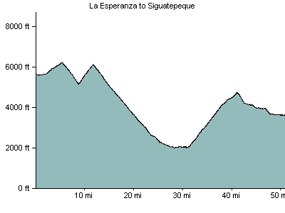
Nancy had a flat right at the lip of the exit to the valley, right after I'd started down, so after waiting awhile I had to ride back up 1000 ft. Her back wheel is hell to work with. (On the elevation profile and distance about 6 miles show extra and a symmetric dip and rise that don't belong there.)
We rode down 4000 ft and then had to start back up. Beautiful territory, even though we could hardly see anything in the muck. Lots of beautiful forest out there.
Lots of hotel choices in Siguatepeque.
- 50 miles/81 kilometers
- Elevation Gain: 4300 feet/1327 meters
- Where we stayed: hotel
- Download GPX file
- Download KML file
Elevation Profile

