Welcome to Hobobiker.com
¿Hablas español? Hay una versión español del sitio aquí y una traducción mala del sitio aquí.
Where we are: Early April 2007
There are new pictures on the photos page...
Parral to Durango and then Zacatecas
About 56 kilometers (35 miles) south Parral as we rode into the town of Las Nieves, the wind blew sheets of dust across the town, the roads and us. It was so impressive to see the wind blowing sideways full of the dust and particles of the arid landscape. We bought a few things to eat from the local Pemex gas station and continued on our way to find Poncho Villa’s Villa in Canutillo. The villa was a run-down complex with a handful of building with large photos and a bit of history about this Mexican who both was a local hero, a famous general of the Mexican revolution, and renegade (from the perspective of the U.S.). After the visit to the museum we decided to find a hotel because we both were sick with a cold and did not have the energy to continue. We found a clean economical room next to the bus stop which we laid low for two days recovering from our ailments.
We headed out two days later feeling somewhat better. The winds where more gentle and the landscape was the same.
(You may want to click the "read more" below to continue - this is a long one.)
Zacatecas from above - and finding directions
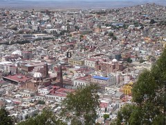
Here's a view of Zacatecas from above. If you click on it you'll get a bigger version and you can see the entire city center. It's an amazing place, with (too many) places to go and things to see. All beautiful, all the old, colonial city.
One of the issues any time we're trying to find out way around is that (1) we don't understand everything people say and (2) they don't necessarily give good directions. For example, if we ask for directions to some site, they may say "straight, straight, straight, just straight". But it turns out that you come to a "T". What do you do then? (Ask again, over and over, of course).
And sometimes there are no signs on a business. In one little town we were looking for an internet "cafe". It turned out there was one, but we had to find our way to the "yellow house". There was no sign at all on said "yellow house", but we did find it and it did in fact have several computers with very slow internet access. When everybody in a town knows where everything is, who needs a sign? read more here... lee mas aquí... »
Zacatecas band winding through the streets
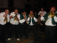
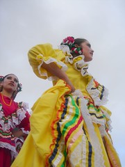
In Zacatecas there is a tradition (I think especially on Saturday nights) of bands winding their way through the streets - kind of a roving party. People follow them around and drink mezcal. We heard one on Saturday night and followed it all over the city - it seemed like we went though every little alley. They were amazing entertainers. They always had something new going. The funniest thing was when we were going through a narrow alley and a dog was barking at us from a balcony above. The whole party stopped, and the band started a piece that involved barking. Every so often they'd stop and we (the whole crowd) would bark back at the dog!
Update: New Pictures and a Podcast (Audio)
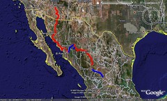
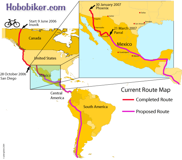
- Our location: We're in Parral, about 200 miles south of Chihuahua, having exited the southeast end of the Copper Canyon region. Nancy did up a wonderful new map of our route (below) so you can see our route.
- New pictures: There are a lot of new pictures on the photos page.
- Podcast: We have started an experimental podcast (audio listen) for you. Click the Podcast button on the top of the page.
Randy at breakfast
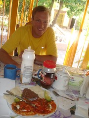
We have decided this dish is an excellent meal to power us on our bike ride. (Protein, Fat, and carbohydrates). Tamales are another food we have discovered is an excellent biking food.
Road down to batopilas
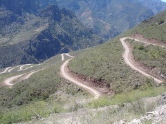
If you look very closely at this photo you may see the foot paths and used by the Tarahumara (Raramuri) Indians to access the resources of this canyon and the way the people of this region travel to and from the outback.
We hitched a ride down to the bottom with four Canadians driving this dusty, teeth rattling, back jarring road. It took around 5 hours to drive this 65k (40 mile) road. Around every corner was a new photo opportunity. We also hitched back with a kind couple from Mexico City who had hired a guide to bring them down and back up to creel.
(Thank you folks for the ride and the time we had to share).
The road was only really wide enough for one car so if another vehicle came around the corner, one of the drivers had to back up or down the road to a spot wide enough for both to squeeze by.
Batopilas aquaduct
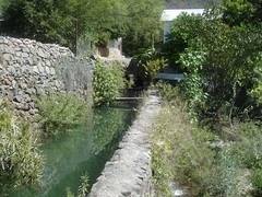
Along the way she swam in the Rio Batopilas river, panned for silver, meet a goat herder, and also a guide on a horse returning from a 3 day trip to Urique and back to Batopolis. Most stunning were the flowering cactus and trees found in this deep desert canyon.